
The Flood Flow Canal (FFC) project envisages Irrigation facility to an area of 2.2 lakh acres in the drought prone areas of Telangana region duly diverting about 20 TMC of surplus waters from Sriramasagar Project during floods and storing in Balancing reservoirs. Under Re-Engineering of the FFC project, the ayacut has been increased to 2.52 lakh acres.
Source: Godavari River, and location: The Head Regulator and Approach Channel for drawing the surplus Flood Flows are located in the foreshore of SRSP Reservoir near Mupkal(V), Balkonda (M), Nizamabad District.
- Latitude : 18o -54’-49”
- North Longitude : 78o -20’- 34” East.
Source RIVER : KADDAM, WHICH IS A TRIBUTARY TO GODAVARI RIVER Sub Basin G10 Catchment area 2590 Sq.Km (1000sq.Miles) Gross storage 7.603 TMC Catchment Shape Fan shaped Falls steeply 1in 350 highest point in the catchment +457 M ( 1500ft) lowest above mean sea level +183 M (600ft) Flood Discharge (observed) 14696 Cumces (5,19,000 cusecs) Designed Discharge 10800m3/sec (3.82 lakh Cusecs) Annual yield calculated at the proposed site 75% Dependability 29TMC 821.M.Cum Average rainfall 947mm (37”) It is under influence of both south west and north east Monsoons. supplementation from SRSPis only 60% Latitude 190 – 07’-00” North Longitude 780 -47’-00” East
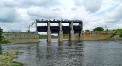
It was reconstructed with an increased spillway capacity adding nine flood gates, and with an increased storage capacity of 127.M.cum raising FRL to +213.30M from +212.10M. An area of 27,519Ha under 98 Villages of Kaddam, Jannaram, Dandepalli, Luxettipet, MancherialMandals of Adilabad District was localised for paddy cultivation under the Project
| Sl No | Classification | Area in Sq.kms. | % Area |
|---|---|---|---|
| 1 | Forest area | 1512.17 | 56.93 |
| 2 | Cultivabale Land | 1645 | 55 |
Kaddam, Jannaram, Dandepalli, Luxettipet, Mancherial of Adilabad District
Operation & Maintenance in Progress


Contact
- Hyderabad, India
- +91 91234-01234
- support@twrdc.com